November 15 – 16th Annual Build Boston Conference
10:00 a.m. – noon
World Trade Center Boston
Panel discussion of Boston’s Municipal Harbor Plan including TBHA’s Vivien
Li.
* * * * * *
JUNE
June 3 – Islands Management Plan Public Meeting
Saturday, 10:00 – 11:30 a.m.
John F. Kennedy Library
Columbia Point, Dorchester
The Boston Harbor Islands Partnership has released their Draft Management Plan for the Islands. Join the Harbor Islands Advisory Council for this public meeting during the 60 day public comment period.
June 19 – Islands Management Plan Public Meeting
Monday, 7:00 – 8:30 p.m.
Salem Maritime National Historic Site Visitor Center
2 New Liberty Street, Salem
The Boston Harbor Islands Partnership has released their Draft Management Plan for the Islands. Join the Harbor Islands Advisory Council for this public meeting during the 60 day public comment period.
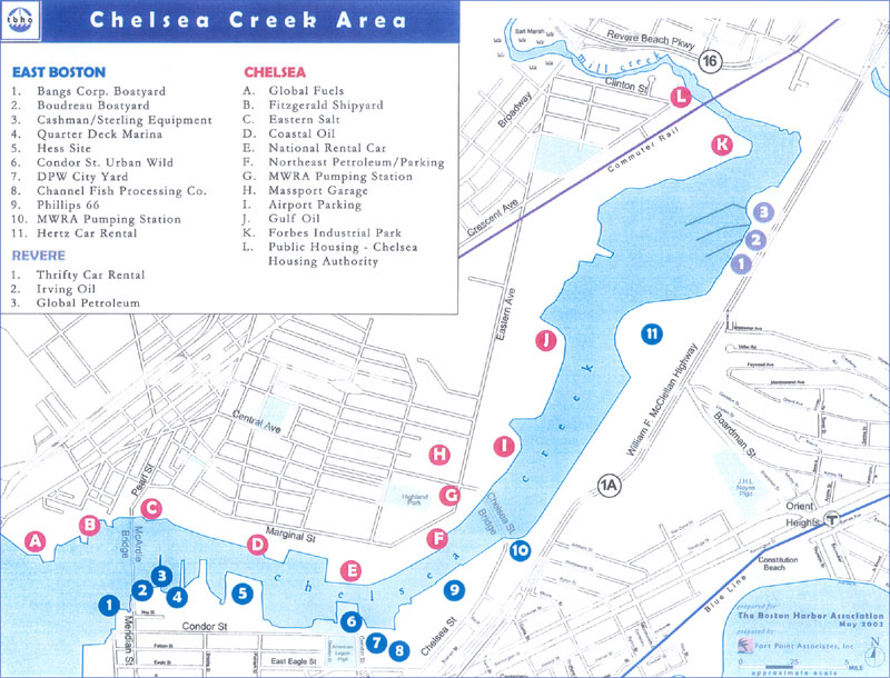
June 20 – Grading the Walk Tour, Waterfront Walking Tour
East Boston Waterfront
Tuesday, 5:30 – 7:00 p.m.
With support from the Department of Environmental Management’s Coastal Access Grant program, The Boston Harbor Association established the “Grading the Walk” program to involve the public in evaluating existing conditions and recommending improvements to the HarborWalk. Join us for this tour of East Boston. Issues such as connections to the Harbor, lighting, seating, and open space will be evaluated. TBHA will incorporate your suggestions into our efforts to improve HarborWalk. Meet at the street level of the Maverick Square T Stop. Free.
June 20 – Islands Management Plan Public Meeting
Tuesday, 7:00 – 8:30 p.m.
Quincy City Council Chambers
1305 Hancock Street, Quincy
The Boston Harbor Islands Partnership has released their Draft Management Plan for the Islands. Join the Harbor Islands Advisory Council for this public meeting during the 60 day public comment period.
June 22 – Islands Management Plan Public Meeting
Thursday, 7:30 – 9:00 p.m.
Hull Senior Center
197 Samoset Avenue, Hull
The Boston Harbor Islands Partnership has released their Draft Management Plan for the Islands. Join the Harbor Islands Advisory Council for this public meeting during the 60 day public comment period.
June 26 – TBHA Harbor Use Committee Meeting
Monday, 8:30 a.m. – 10:00 a.m.
TBHA Office, 374 Congress Street, Suite 609, Boston
The Boston Harbor Association’s Harbor Use Committee Meeting Agenda is as follows:
1. Update and discussion on Residences at 371-401 D Street-Robert Maloney, Managing Director, Cathartes Investments, and Jim Lydon, Daylor Consulting Group (public comment period on Draft Project Impact Report ends 10 July 2000).
2. Update and discussion on proposed South Boston development proposals (note: comment period for The McCourt Company’s Gateway Project ends 14 July, and comment period for Pritzker’s Fan Pier Development ends 5 July). Light refreshments will be available.
June 26 – Islands Management Plan Public Meeting
Monday, 7:00 – 8:30 p.m.
Winthrop Senior Center
35 Harvard Street, Winthrop
The Boston Harbor Islands Partnership has released their Draft Management Plan for the Islands. Join the Harbor Islands Advisory Council for this public meeting during the 60 day public comment period.
June 27 – Islands Management Plan Public Meeting
Tuesday, 5:00 – 6:30 p.m.
Faneuil Hall, Boston
The Boston Harbor Islands Partnership has released their Draft Management Plan for the Islands. Join the Harbor Islands Advisory Council for this public meeting during the 60 day public comment period.
June 28 – Special Preview
“Boston by Sea: Living History in Story, Sites, and Songs”
The Boston Harbor Association will be hosting a special preview of “Boston by Sea: Living History in Story, Sites, and Songs” on Wednesday evening June 28 at the University Park Hotel @ MIT, 20 Sidney Street, Cambridge (near Central Square). “Boston by Sea” is an interactive program involving theatre, song, and film that traces the history of Boston Harbor. A reception at 5 p.m. will precede the performance at 6:15 p.m. Admission is free to both the reception and the performance.
June 28 – Islands Management Plan Public Meeting
Wednesday, 7:00 – 8:30 p.m.
Roxbury Multi Cultural Center
317 Blue Hill Avenue, Roxbury
The Boston Harbor Islands Partnership has released their Draft Management Plan for the Islands. Join the Harbor Islands Advisory Council for this public meeting during the 60 day public comment period.
June 29 – Islands Management Plan Public Meeting
Thursday, 7:00 – 8:30 p.m.
Waltham Government Center, Arthur Clark Building, 119 School Street, Waltham
The Boston Harbor Islands Partnership has released their Draft Management Plan for the Islands. Join the Harbor Islands Advisory Council for this public meeting during the 60 day public comment period.
JULY
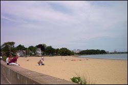
July 1 – Back to the Beaches Celebration
Saturday, 12:00 – 4:00 p.m.
Carson Beach, South Boston
Join us for a free, fun, family-oriented “Back to the Beaches” celebration sponsored by the Metropolitan District Commission, the City of Boston, and The Boston Harbor Association. This event will feature concerts, volleyball, water sports, amusements, and much more. Prizes and giveaways from KISS 108 FM. Contact TBHA at (617) 482-1722 for additional information.
July 2 – Back to the Beaches Celebration
Sunday, 12:00 – 4:00 p.m.
Pleasure Bay, South Boston
Join us for a free, fun, family-oriented “Back to the Beaches” celebration sponsored by the Metropolitan District Commission, the City of Boston, and The Boston Harbor Association. This event will feature concerts, volleyball, water sports, amusements, and much more. Prizes and giveaways from KISS 108 FM.
July 12 – Tall Ships Celebration at the Boston Marine Industrial Park
Wednesday, 5:00 p.m. – 7:00 p.m.
Join friends and supporters of The Boston Harbor Association for a reception at the Boston Marine Industrial Park to celebrate the arrival of the Tall Ships. The reception will be in the credentials-only area of the Admiral’s Yard, adjacent to Dry Dock Avenue in view of the Tall Ships berths. Guests will be able to move freely before and after the reception to see the Tall Ships. Public Boarding of Tall Ships will be from 10:00 a.m. to 5:00 p.m., and viewing from the piers will be open until 10:00 p.m. Tickets are limited and will be issued on a first-come, first-serve basis. Reservation and payment of $50 per ticket must be received no later than July 3, 2000. To reserve space, please send a check, payable to The Boston Harbor Association. Mail Payment to:
TBHA
374 Congress Street, Suite 609
Boston, MA 02210
Credentials and transportation information will be forwarded following receipt of payment.
July 13 – Thursday – Cruise Featuring Harbor Islands and Tall Ships, 5:30 p.m. – 7:30 p.m. (Boarding begins at 5:00 p.m.)
Join The Boston Harbor Association for an early evening harbor tour. Enjoy the special on-water views of the Boston Harbor Islands and Tall Ships participating in Sail Boston 2000. $30/Person. Light refreshments served.
Reservations required. Call for reservations and departure location.
SOLD OUT
July 23 – Back to the Beaches Celebration
Sunday, 12:00 – 4:00 p.m.
Wollaston Beach, Quincy
Join us for a free, fun, family-oriented “Back to the Beaches” celebration sponsored by the Metropolitan District Commission, the City of Boston, and The Boston Harbor Association. This event will feature concerts, volleyball, water sports, amusements, and much more. Prizes and giveaways from KISS 108 FM. Contact TBHA at (617) 482-1722 for additional information.
July 26 – Reinventing the South Boston Waterfront, 6 p.m.
Federal Reserve Bank
600 Atlantic Avenue
Boston (across from South Station)
A Discussion on the “Opportunities for a Livable Seaport District.” Sponsored by Boston Society of Landscape Architects. TBHA’s Vivien Li will moderate the panel discussion. Free.
July 29 – Back to the Beaches Celebration
Saturday, 12:00 – 4:00 p.m.
Winthrop Beach
Join us for a free, fun, family-oriented “Back to the Beaches” celebration sponsored by the Metropolitan District Commission, the City of Boston, and The Boston Harbor Association. This event will feature concerts, volleyball, water sports, amusements, and much more. Prizes and giveaways from KISS 108 FM.
July 30 – Back to the Beaches Celebration
Sunday, 12:00 – 4:00 p.m.
Constitution Beach, East Boston
Join us for a free, fun, family-oriented “Back to the Beaches” celebration sponsored by the Metropolitan District Commission, the City of Boston, and The Boston Harbor Association. This event will feature concerts, volleyball, water sports, amusements, and much more. Prizes and giveaways from KISS 108 FM. C
SEPTEMBER
September 16 – Coastsweep
Join The Boston Harbor Association, NStar, and the Mystic River Watershed Association as they clean the lower Mystic River as part of the National COASTSWEEP Clean up on Saturday, 16 September, 9:00 a.m. – 12:00 noon. We will be repainting a small fish pier and removing debris from the banks of the lower Mystic River in Somerville, MA behind Assembly Square Mall on the Mystic Valley Parkway. A light breakfast, lunch, prizes, bags and gloves will be provided. To participate,
Driving Directions to the cleanup site:
Please Follow the Signs for COASTSWEEP!
- Take 93 North
- Exit 28 (Somerville, Sullivan Square)
- At end of ramp take a right onto Cambridge Street
- Once on Cambridge Street immediately get into the far left-hand lane
- At this stop light go straight and veer left into a rotary
- Continue to stay left on rotary
- After passing the Route 1 North sign on your right, get into the far right hand lane (watch for merging traffic)
- Turn right (your only choice is to turn right) onto Main Street
- Stay in right-hand lane and follow Main Street for a few blocks
- After passing a sign saying “Entering Somerville”, immediately turn right onto Assembly Square Drive
- Stay on Assembly Square Drive (You will pass a Circuit City and a Loews Theater on your left-hand side)
- At the first stop sign take a right onto Foley Street (Before Penske Auto Center)
- Follow this road past a Global gas station on your right-hand side
- Continue to follow the winding road and the signs for COASTSWEEP, which will lead you to the parking lot of the Winter Hill Yacht Club
Directions by Public Transport:
- Take the Orange Line to Sullivan Square
- Take the # 90 Bus to Assembly Square Mall
- Get off the bus at the corner of Assembly Square Drive and Foley Street
- Walk down Foley Street towards the Global gas station
- Follow the winding road and the signs for COASTSWEEP, which will lead you to the parking lot of the Winter Hill Yacht Club. The walk should take 5 – 10 minutes
If you have any questions please feel free to contact The Boston Harbor Association at (617) 482-1722.
“Grading the Walk” Waterfront Walking Tours
September 21st, October 3rd & October 24th
Join members of The Boston Harbor Association and our partners, the National Park Service and Boston Natural Areas Fund, for these “Grading the Walk” waterfront walking tours. You will help evaluate existing conditions and recommend improvements for the HarborWalk. Issues such as connections to the Harbor (water transportation, boat ramps, beach access), lighting, special features, connections to public transportation, seating, restrooms, and open space will be evaluated. Your suggestions will be incorporated into our efforts to improve HarborWalk. Wear comfortable walking shoes.
September 21 (Thursday), 5:30 – 7:00 p.m. – Charlestown Navy Yard / Boston National Historical Park
Meet at 5:30 p.m. at Pier 4, Charlestown Navy Yard Water Shuttle. Sean Hennessey, National Park Service, and Vivien Li, The Boston Harbor Association, will lead the tour of the Boston National Historical Park and the Charlestown Navy Yard. Water shuttle departs from Long Wharf at 5:00 p.m. and 5:15 p.m. to Pier 4, Charlestown Navy Yard ($1 fare).
OCTOBER
October 3 (Tuesday), 5:00 p.m. – 7:00 p.m. – East Boston Waterfront
Meet at 5:00 p.m. on the street level Maverick T Station (blue line) in East Boston. Valerie Burns and Lauri Webster of the Boston Natural Areas Fund and TBHA’s Vivien Li will lead the tour. We will focus on the area from Central Square to the Meridian Street Bridge. Sites which we will visit include: Liberty Plaza in a Designated Port Area with a water transit dock; Umana / Barnes Middle School with waterfront ballfields and the City’s first skateboard park; and Shore Plaza residential development with waterfront walkways. Please be prepared for a 2 mile walk.
October 24 (Tuesday) – HarborWalk Luncheon
Join TBHA members and friends at a 24 October 2000 luncheon presentation on the status of the HarborWalk. Slides from “Grading the Walk” tours over the last 18 months will be shown, covering the South Boston, Downtown, North End, East Boston, and Charlestown waterfronts. The luncheon is from 12 noon to 1:30 p.m. at TBHA’s offices, 374 Congress Street, Boston.
NOVEMBER
November 15 – 16th Annual Build Boston Conference
10:00 a.m. – noon
World Trade Center Boston
Panel discussion of Boston’s Municipal Harbor Plan including TBHA’s Vivien
Li.
November 19
6:30 p.m. – 9:30 p.m.
The Mall at Chestnut Hill
Start out the holiday shopping season by purchasing a $10 ticket to Charity Night, a private evening of shopping to benefit participating organizations, including TBHA.
DECEMBER
December 13 – “Harboring Boston’s Future”, 6 PM
Rabb Lecture Hall, Boston Public Library
Copley Square
Slide presentation by The Boston Harbor Association’s Executive Director Vivien Li on Boston’s waterfront.
13 December 2000, 6 p.m., Rabb Lecture Hall, Boston Public Library, Copley Square. Part of The Boston Society of Architects’ “Exploring Design” Lecture Series. Free.